n the heart of Buckinghamshire, along a quiet stretch of the River Ouse, lies the largely forgotten story of Hasley — a once-prominent manorial landscape whose roots reach deep into England’s medieval past. The area’s significance, though often overlooked today, is well documented in royal charters, estate records, and parish surveys spanning more than a thousand years.
Historically, the Ouse marked both a physical and political boundary. Its course shaped trade, agriculture, and the territorial divisions of Anglo-Saxon and Norman England. Hasley occupied a central position within this network, bordered by Radclive to the north, Tingewick to the south, and the fortified market town of Buckingham to the southeast. Each played a distinct role in the regional economy, as evidenced by surviving tax rolls, manorial accounts, and agricultural leases.
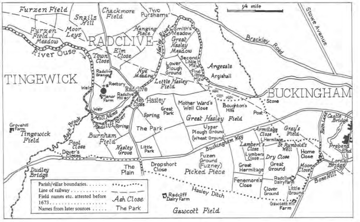
By the late medieval period, Hasley’s prominence began to wane, gradually giving way to the adjoining settlement of Thornton. Yet traces of its former importance remained visible in field names and boundary markers — most notably “Hazley Ditch Furlong,” a feature that persisted in local records until the Enclosure Acts of 1821. Such survivals, rare though they are, underscore the endurance of Hasley’s identity long after its administrative functions faded.
Throughout the course of history, the legacy of Hasley appeared to wane, overshadowed by neighboring territories. Yet, an exception persists in Gawcott, where the geographical feature ‘Hazley Ditch Furlong’ survived until the Enclosure Acts of 1821. The persistence of this nomenclature speaks to the durable influence of Hasley upon the local vernacular.
The River Ouse itself served as a constant thread through these centuries of change. During times of political unrest — from the Hundred Years’ War to the Wars of the Roses — the river corridor became both a frontier and a lifeline, linking local estates to the broader conflicts that defined England’s history.
Oral tradition preserved much of what written record omitted. Names such as “Dropshort,” “Fuzney,” “Mother Ward’s Well Close,” and “Boughton’s Hills” appear in eighteenth- and nineteenth-century maps as echoes of earlier usage, revealing layers of occupation and adaptation from the Plantagenet through the Tudor and Elizabethan eras.
One particularly evocative site is Hasley Grove, once a substantial woodland and later the area now known as “The Golf Links Fields.” Its transformation from forested manor land to leisure ground mirrors the broader economic and social transitions of the Industrial and Victorian ages.
While the Domesday Book provides only a cursory reference to Hasley, later royal clarifications — notably under Edward III and Queen Anne — reaffirmed its territorial and fiscal standing within Buckinghamshire. Families such as the Bartons, Ingletons, and Tyrrells are recorded as successive holders of the estate, their arms appearing in heraldic rolls and parliamentary records that chart the descent of the Hasley barony through successive centuries.
Taken together, these sources portray Hasley not merely as a geographic locality but as a durable element of England’s feudal heritage. Its recorded existence as a historic feudal barony, reaffirmed in modern registries (NFRA H1223210-21; The London Gazette Notice 4290557, 2023; BENR #720713), places it among the few manorial titles to retain continuous legal and historical identity from the Anglo-Saxon era to the present day.
The Barony of Hasley thus endures as more than a nominal title. It stands as a record of land, lineage, and service — a small but meaningful chapter in the long history of Buckinghamshire and of England itself.